
Wêne:Kurdish-inhabited area by CIA (1992) box inset removed.jpg

Mezinahiya vê pêşdîtinê: 735 × 599 pîksel. Resolusyonên din: 294 × 240 pîksel | 589 × 480 pîksel | 975 × 795 pîksel.
Dosyeya orjînal (975 × 795 pixel, mezinbûnê data: 556 KB, MIME-typ: image/jpeg)
Pkk
Danasîn
| Danasîn |
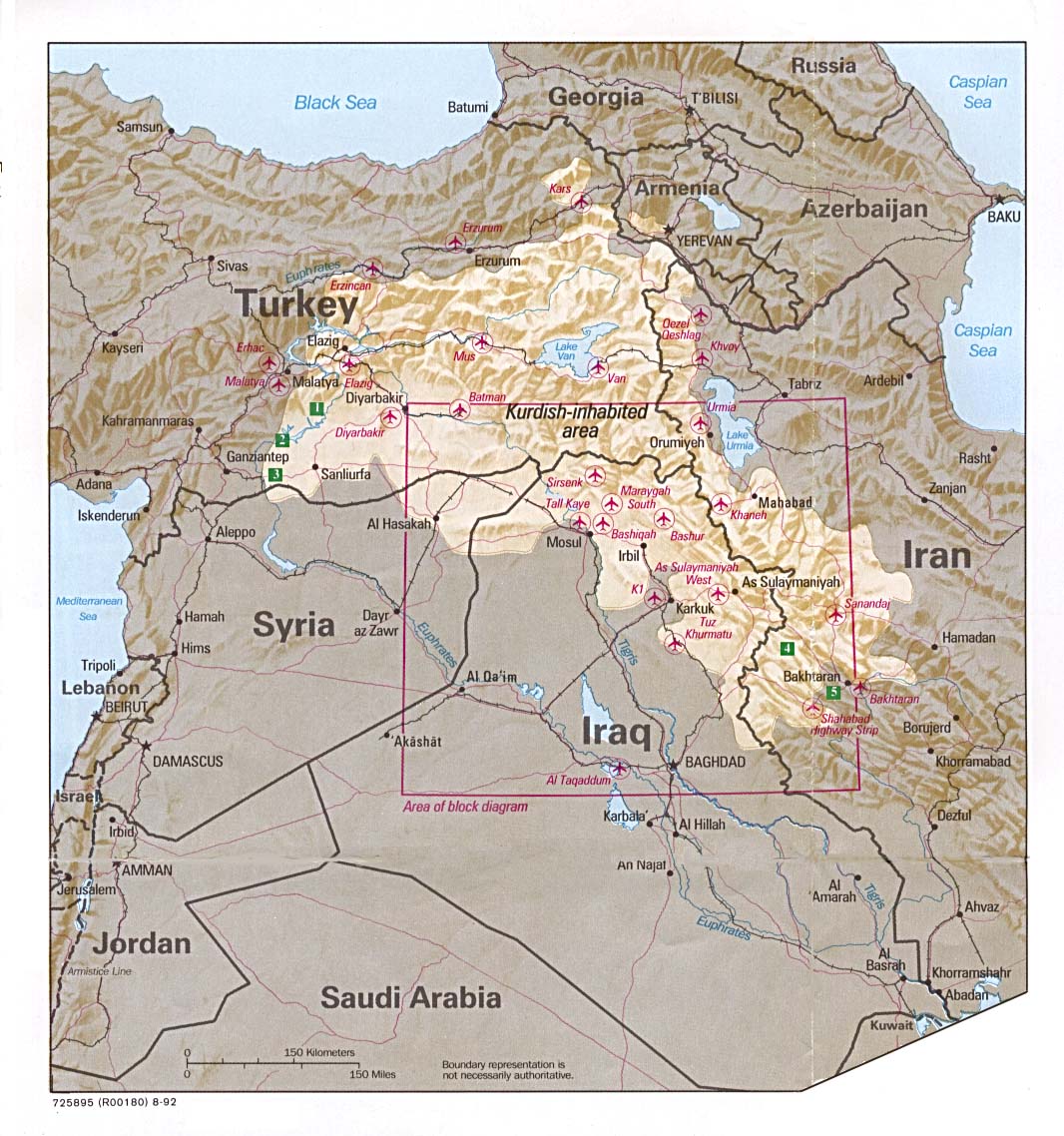
English: Kurdish-inhabited area, by CIA (1992)
Ελληνικά: Περιοχές κατοικούμενες από Κούρδους κατά τη CIA (1992) |
| Tarîx | |
| Çavkanî |
Perry-Castañeda Library Map Collection at The University of Texas at Austin [1] linked from Perry-Castañeda Library Map Collection at The University of Texas at Austin |
| Xwedî |
English: Source stated "The following maps were produced by the U.S. Central Intelligence Agency, unless otherwise indicated." |
| Guhartoyên din |
|


_box_inset_removed.jpg)
Lîsans

|
This image is a work of a Central Intelligence Agency employee, taken or made as part of that person's official duties. As a Work of the United States Government, this image or media is in the public domain in the United States.
|

|
See also
- File:Kurdish lands 92.jpg - cropped and down-scaled version of same map apparently first uploaded at English wikipedia in 12 May 2003 from [2] and transferred to Commons on 2007-09-08
- Image:Kurdish lands 92 cropped.jpg - apparently cropped on 15 Jun 2003 (see w:en:Talk:Kurdish people/Archive 1) moved to Commons on or before 2006-12-16 but deleted on 9 February 2007 with comment: Superceeded ny Image:Kurdish-inhabited area by CIA (1992).jpg

.jpg)
Dîroka daneyê
Ji bo dîtina guhartoya wê demê bişkoka dîrokê bitikîne.
| Tarîx/Wext | Wêneyê biçûk | Mezinahî | Bikarhêner | Şirove | |
|---|---|---|---|---|---|
| niha | 10:47, 6 tebax 2016 | | 975 x 795 (556 KB) | wikimediacommons>Kintetsubuffalo | User created page with UploadWizard |
Bikaranîna pelê
Ev rûpelên li jêr vê dosyeyê bi kar tînin:
_box_inset_removed.jpg)